> ## Documentation Index
> Fetch the complete documentation index at: https://docs.firebolt.io/llms.txt
> Use this file to discover all available pages before exploring further.

<AgentInstructions>

## Submitting Feedback

If you encounter incorrect, outdated, or confusing documentation on this page, submit feedback:

POST https://docs.firebolt.io/feedback

```json
{
  "path": "/reference-sql/functions-reference/geospatial/st_asgeojson",
  "feedback": "Description of the issue"
}
```

Only submit feedback when you have something specific and actionable to report.

</AgentInstructions>

> Reference material for ST_ASGEOJSON function

# ST_ASGEOJSON

Converts shapes of the `GEOGRAPHY` data type to the [GeoJSON](https://datatracker.ietf.org/doc/html/rfc7946) format.

The [GeoJSON standard](https://datatracker.ietf.org/doc/html/rfc7946) specifies that GeoJSON points are WGS 84 coordinates, and GeoJSON line segments are planar edges, meaning straight cartesian lines. However, contrary to that, in Firebolt, the line segments are interpreted as geodesic arcs.

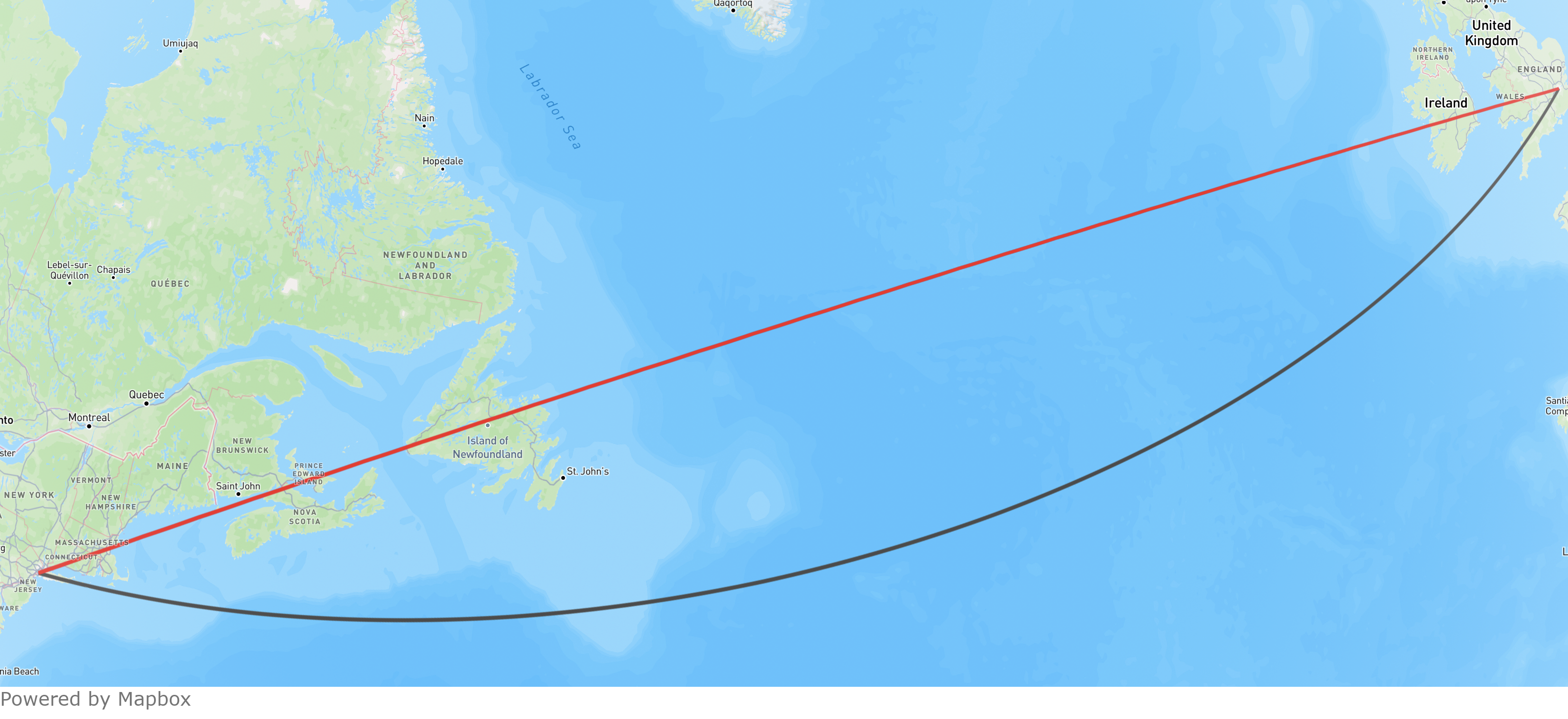
The following image shows an extreme case of the difference between these.
Both lines show the LineString from the GeoJSON string `{"coordinates": [[-0.12457505963581639,51.5006710219584],[-74.04448100812115,40.68923977267272]],"type": "LineString"}` that connect the Statue of Liberty in New York City and Big Ben in London. The gray line represents the LineString as a straight Cartesian line, following the GeoJSON standard. In contrast, the red line interprets the LineString as a geodesic arc, consistent with Firebolt's approach.

<img src="https://mintcdn.com/firebolt/2dZYiQcds9pQFLHr/assets/images/geography/geojson_difference.png?fit=max&auto=format&n=2dZYiQcds9pQFLHr&q=85&s=684e99ec3d8d9fefcccd23e5a76f5d2f" alt="An example showing the interpretation of a GeoJSON string according to the GeoJSON standard and in Firebolt." width="600" data-path="assets/images/geography/geojson_difference.png" />

## Syntax

```sql theme={"theme":{"light":"github-light","dark":"github-dark"}}
ST_ASGEOJSON(<object>)
```

## Parameters

| Parameter  | Description                                          | Supported input types |
| :--------- | :--------------------------------------------------- | :-------------------- |
| `<object>` | The `GEOGRAPHY` object to convert to GeoJSON format. | `GEOGRAPHY`           |

## Return Type

`ST_ASGEOJSON` returns a value of type `TEXT`.

## Example

The following query creates a `GEOGRAPHY` object from the WKT representation of a Point at specified longitude and latitude coordinates and converts it to GeoJSON format:

```sql theme={"theme":{"light":"github-light","dark":"github-dark"}}
SELECT ST_ASGEOJSON(ST_GEOGFROMTEXT('POINT(-73.98551041593687 40.75793403395676)')) AS result
```

**Returns**

| result (TEXT)                                                           |
| :---------------------------------------------------------------------- |
| `{"type":"Point","coordinates":[-73.98551041593687,40.75793403395676]}` |